The Riverside Walkway leading from the Wairoa lighthouse to Whakamahia beach is 7.7kms long. If you walk this will take you about 1.5 hours, if you bike it will take you about 30 mins one way.
The Wairoa area, especially along the river and coastline, was densely populated before settlers arrived and has a rich Māori history. Many of the sites noted in this brochure are also recorded as historic plaques. If you would like additional information we recommend you visit the Wairoa Museum.
We hope you enjoy your walk or bike ride along the Wairoa river to Whakamahia beach!
Te Wairoa Hōpūpū Hōnengenenge Mātangi Rau (the long, bubbling, swirling, uneven waters) is the full name of the Wairoa River and refers to its turbulence and hidden currents. The Ruakituri, Hangaroa, Mangapoike, Mangaaruhe and Waiau Rivers are all tributaries of the Wairoa River.
The first bridge was built in 1888 and damaged in the 1931 Hawke’s Bay earthquake. The second bridge was opened in 1933 and destroyed by Cyclone Bola in 1988. The present bridge was opened in February 1990 by Queen Elizabeth II.
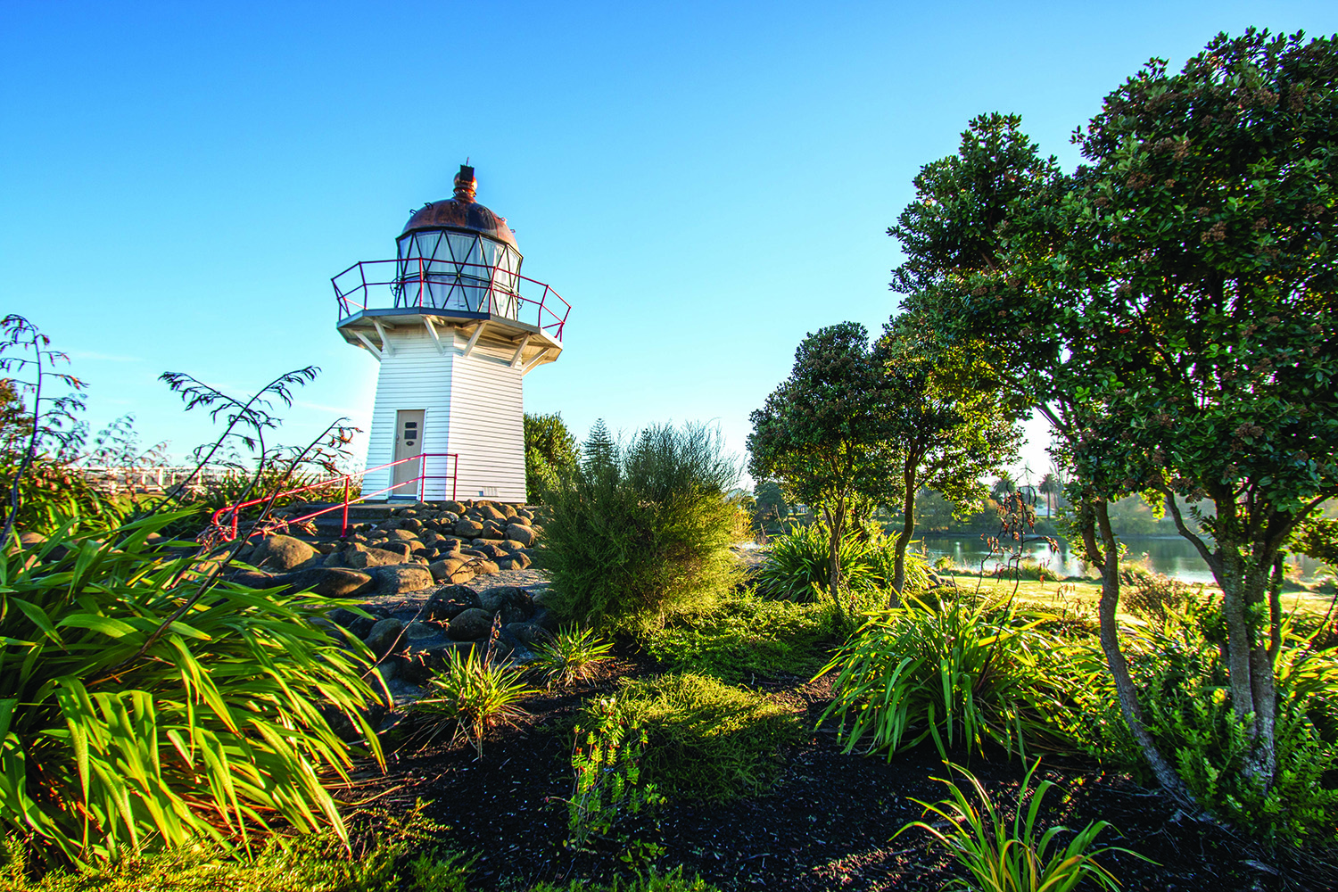
The Portland Island Lighthouse was brought from Portland Island where it was no longer needed after a fully automated light was installed. It was partly re-erected in Wairoa in 1961.
Osler’s Bakery was established in 1905. It was partly destroyed in the 1931 Hawke’s Bay earthquake and then rebuilt. Osler’s has won several awards for its tasty pies. For travellers it is a must do stop to enjoy pie.
The Wairoa Museum building was originally opened in 1915 as the commercial Bank of Australia. Italianate facades were commonly used by financial institutions in the late nineteenth and early twentieth centuries. The museum opened on this site on 8 December 2001 and has recently been re-developed.
This pā extended over two acres from the old Post Office site to the present Clyde Hotel. Tane-te-kohurangi, also known as Moewhare, was the last chief.
The Village Green was originally the site of the second Wairoa Courthouse which was later moved. A Post Office with a large clock tower was built. This was severely damaged in the 1931 earthquake. Coronation Square was named in honour of King George V at about the time of his coronation, as was the Band Rotunda that previously stood on this site.
This was Wairoa’s first cinema. Originally built in 1928, it collapsed in the 1931 Hawke’s Bay earthquake but was quickly rebuilt. In the late 1960s the cinema closed its doors but was reopened in the mid-1990s, reinstated to its former glory. Now the Gaiety Theatre is showing movies from Wednesday to Sunday every week.
This wharf is a reminder of the time when Wairoa was a river port. Wool, flax fibre, meat and dairy products were the main exports and each company had its own wharf or jetty. The flax was transported by horse trains from Ohuia, a farm located on the east side of the Wairoa River.
Originally 40 Norfolk Pines were planted along the eastern end of Marine Parade in 1923 by the manager of the Freezing Works, Mr Mills. It is possible that they were part of a longer avenue as other individual Norfolk Pines of a similar age are to be found along the river bank.
The Blockhouse was erected in September 1865 on the land now used by the Tennis Club. Lambton Square was the parade ground. The first courthouse and jail were also situated here. Part of the jail was used in the construction of Wairoa’s first hospital, built on the corner of Lambton Square, in 1886.
Kai-mangō pā was a populous kāinga. Oral descriptions depict the extremities of which almost join up with another kāinga called Manuka-nui pā (6) further along the river where the library now sits. When Tapuwae was the chief this pā was used by him as a centre of hospitality and political discussion.
This pā belonged to Te Maaha, the brother of Tapuwae. It was situated where Grey Street is now.
A loan of seventy-eight thousand pounds was obtained by the Wairoa Harbour Board in late 1910 to carry out work and erect retaining walls in the river so that a permanent opening in the bar could be created. Work started in 1912 and was not completed until 1916. Papa rock was obtained from the quarry at Ohuia.
Tupaheke is the guardian taniwha of the Wairoa River as it enters the sea. He is said to have arms like a great crab and is harmless to local people. However, according to local tradition, if a stranger touches the rock it is said they will suffer misfortune.
Tapuwae was the son of Te Okuratawhiti and Hinepehinga. His first wife was Te Rauhina and his home was on the western side of the river. He was in a continual struggle with his brother Te Maaha as to where the entrance to the sea was. (approximately in the 1400’s)
Te Maaha was the younger brother of Tapuwae. He lived on the eastern side of the river and was happy when the channel was on the eastern side of ther river because he had a shorter distance to go to catch fish. The bar is said to still shift today at the whim of the two brothers as they continue to struggle.
Te Rauhina was one of the wives of Tapuwae. She was known to be a lovely, forgiving and peace talking person, her home was a sanctuary for others. She lived on a small island with her three children. During heavy flood the river had created a channel and separated what was approximately ten acres from the mainland. The island gradually disappeared over time as the Wairoa River changed its course with the opening of the river bar.
In earlier days before the arrival of the Europeans the path that the Wairoa river took was different from today. The river mouth moved bigger distances than today and would move from where the Whakamahia lagoons are today all the way to the eastern side of the river at times.
Ihu-tupu, the grandson of Tapuwae, occupied Ahi-paniki pā. It was defended by a wall and palisaded and occupied all the land from the residence of the late A. Lewis to Rangi-houa pā on the old Pilot Station.
Rangi-houa pā was a double pā. The southern end belonged to Tupaheke and the northern end to Kai aha. It was defended by earthworks, the western and northern walls still being visible. It was only open to attack on these two sides as it was virtually unassailable from the river sides. Rangi-houa pā was densely populated. On the flats at the top of Rangi-houa kumara used to be planted.
There was a wide flat between Kōpu Road and the edge of the river where karaka trees grew. This area has gradually become smaller over the years as the river has changed course.
Pilot Hill offers amazing views as far as Māhia and Cape Kidnappers. This hill has an extensive history and had a few different names over time. The people that first arrived on this land named it Rangi-houa (Māori for ‘reach for the sky’). After that, when people started arriving on ships and navigating the bar it was called ‘The Heads’. A system of flags was introduced to show what condition the bar was in for crossing. Later on a system of masts and balls was used to communicate the conditions of the bar. The pilots would investigate the conditions of the bar by boat and then erect the balls on the mast accordingly to the condition.
The river bar could be closed to shipping for weeks at a time due to tidal conditions and many boats fell victim to its unpredictable movement.
The Pill boxes along Whakamahia Road are relics of WWII. They are gun emplacements situated there to warn against possible Japanese invasion during WWII.
The name Whakamahia means ‘put to work’. In earlier days the hapū around the Whakamahia lagoons and Rangi-houa were known to be good at gardening. This area was used to plant vegetables and crops. People from the surrounding pā were put to work on this land, hence the name Whakamahia.
The original name of the lagoons is Te Mango referring to the barracuda fish that are still found here today. The two lagoons have a rich Māori history. The deeper and larger lagoon, which is closer to the river mouth, was named Whakamahia while the much shallower lagoon to the west was named Whakamahi.
The lagoon and its associated tidal flats are a nature reserve and it’s a good spot for bird watching. Among the birds to be spotted are Gulls, Mallards, Canadian Geese, Pied Stilts, Oyster Catchers, Banded Dotterels and sometimes Royal Spoonbills and White Heron. Some species remain at the lagoon throughout the year while others, like the Godwit and Golden Plover, migrate around the world to nest in the northern hemispere each New Zealand autumn and return in spring.
The lagoons are also an important fishery habitat for whitebait, long finned eel, flounder and kahawai.
The European history dates back to October 1769 when Captain Cook recorded the presence of the river mouth. Later in the 1830s, trade in flax harvested from the nearby flats developed, along with the establishment of a whaling station at the Heads.
In 1887 the Mein brothers owned huge areas of surrounding land which farmed twenty three thousand sheep. In 1905 the Government purchased land from the Mein brothers for subdivision into smaller blocks to settle more farmers. From this came Whakamahi station. Its first owner was Mr E Jefferson.
When Ruawharo arrived at Whakamahia Beach with the Takitimu waka it is said that he had spread sand that he brought from Hawaiki along the beach. Therefore Whakamahia beach is also known by the name Tahuna-mai-Hawaiki which refers to Ruawharo spreading the sand from Hawaiki. Whakamahia beach became a burial ground for people of those days. One of the people buried here was Tapuwae.
Today Whakamahia Beach is part of ‘Space Coast New Zealand’ (the stretch of Wairoa district coastline from which space launches from Launch Complex 1 on Māhia Peninsula can be viewed). It is also a most loved jewel of the Wairoa District. It is very unique with its black sand and driftwood.
Due to a dangerous undertow, it is not adviseable to swim at this beach but it is great for fishing. Some of the species that can be caught here include Snapper, Kahawai and Gurnard.
This area is also a popular destination for self-contained Freedom Campers as camping at the beach front is possible. Recently public toilets and picnic tables were installed to accommodate increased visitors to the area.
Sunsets from Whakamahia Beach are impressive, especially when it is overcast as the colours of the setting sun will display beautifully in the clouds.
It is a great spot to spend an afternoon reading a book, fishing, having a picnic, collecting driftwood and building sculptures on the beach.
There are picnic tables at Spooners Point and also at Whakamahia Beach, so pack a picnic and enjoy an afternoon along the river and beach.
Public toilets have also been installed at Whakamahia Beach for your comfort.
If you are travelling in a self contained campervan, just park up along Kopu Road, Pilot Hill or Whakamahia Beach and enjoy up to three nights of camping in a relaxed environment.
Both the Wairoa River as well as Whakamahia Beach are rich with fish. Bring your rod and catch your dinner.
Bait and fishing equipment can be purchased at the local service stations, Estway Sports and Wairoa Motorcycles.
Disclaimers and Copyright
While every endeavour has been taken by the to ensure that the information on this website is
accurate and up to date, shall not be liable for any loss suffered through the use, directly or indirectly, of information on this website. Information contained has been assembled in good faith.
Some of the information available in this site is from the New Zealand Public domain and supplied by relevant
government agencies. cannot accept any liability for its accuracy or content.
Portions of the information and material on this site, including data, pages, documents, online
graphics and images are protected by copyright, unless specifically notified to the contrary. Externally sourced
information or material is copyright to the respective provider.
© - www.visitwairoa.co.nz / +64 6 838 7440 / isitewairoa@wairoadc.govt.nz